
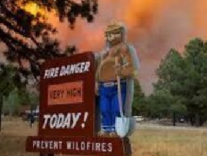
The Biscar Fire started on July 18, 2026 within Lassen County. It grew quickly with warm temperatures and strong winds pushing it eastward across Highway 395. It is currently estimated at around 40,000 acres with 5% containment and has crossed the state line into Nevada. There was about 10,000 acres of growth today (July 20), primarily to the south and east. The threat of thunderstorms in the area increases through Thursday, bringing chances for scattered rain, strong winds, and lightning.
Evacuation Orders: Orders have been issued for the following areas - LAS-543, LAS-551-A, LAS-551-B, LAS-551-C, and LAS-553. An evacuation order is issued when there is an immediate threat to life. This is a lawful order to LEAVE NOW. The area is lawfully closed to public access.
Evacuation Warnings: Warnings have been issued for the following areas- LAS-54, LAS-545, and LAS-555 An evacuation order means there is a potential threat to life and/or property. Those who require additional time to evacuate, and those with pets and livestock should leave now.
Interactive Evacuation Map is available through https://protect.genasys.com/
For shelter information call (530) 254-4500: or visit the Lassen County Sheriff's Office Facebook: https://www.facebook.com/LassenSheriff/
Highway Closures: Highway 395 is closed in both directions, from 1 mi north of Viewland /at Smoke Creek Rd to 7 mi north of Ravendale (Lassen Co), Motorists are advised to use an alternate route. https://roads.dot.ca.gov/?roadnumber=395 Highway 395 will be reopened as soon as it is safe, please check the website.
Smoke Impacts: Please visit https://fire.airnow.gov/?lang=en#7.34/40.599/-119.644 for smoke information from the Biscar Fire. Fore information about the impacts of smoke, and ways to protect your health, please visit https://www.airnow.gov/air-quality-and-health/fires-and-your-health/
Fire Restrictions: The Bureau of Land Management issued seasonal fire restrictions effective July 15th for BLM-managed public lands within Lassen, Modoc, Plumas, Sierra, Siskiyou and Shasta counties in California and Washoe County, Nevada. These seasonal restrictions are in addition to the year-round, statewide fire prevention order. These fire orders for Applegate and Eagle Lake field offices are in place to help prevent wildfires and will remain in effect until further notice.
The fire restrictions prohibit campfires and barbecues except within established campfire rings and barbecue grills in certain designated recreation sites: Read more at https://www.blm.gov/announcement/blm-announces-seasonal-fire-restrictions-ne-california-nw-nevada-0
About the Bureau of Land Management - Northern California District. The BLM’s Northern California District manages about 3.5 million acres of public lands, covering a diverse landscape, ranging from the arid and rugged Great Basin to the fog shrouded forests of the North Coast. The Redding-based district office oversees field offices in Alturas, Arcata, Redding and Susanville and a field station in Cedarville. The district contains two distinct regions. On the east, the Applegate and Eagle Lake field offices oversee vast expanses of public lands in a high desert landscape, including about a million and a half acres in far western Nevada. Small communities depend on public lands for economic benefits, primarily through livestock grazing, and tourism uses ranging from hunting to mountain biking. These lands provide habitat for 14 wild horse herds and special status species, such as greater sage grouse. On the west, the Arcata and Redding field offices manage smaller, scattered blocks of public land with more emphasis on recreation demands from urban areas.