
Filter - control incident types displayed on map.
Zoom to your location
Reset map zoom and position
Show Legend
Unit Information
99 Agency Rd Lapwai Idaho 83540
Idaho
0
99 Agency Rd Lapwai Idaho 83540
Idaho
0
Highlighted Activity
Northern Rockies Team 1, Incident Commander Bea Day Location: Approximately 5 miles south of Copeland, Idaho Start Date: 7/15/2026 Cause: Undetermined, under investigation Size: 593 acres Resources: 170 Total Personnel; 3 Dozers; 5 Helicopters; 5 Hand Crews; 13 Engines Key Message: Northern Rockies Complex Incident Management… Read more
Publication Type: News -
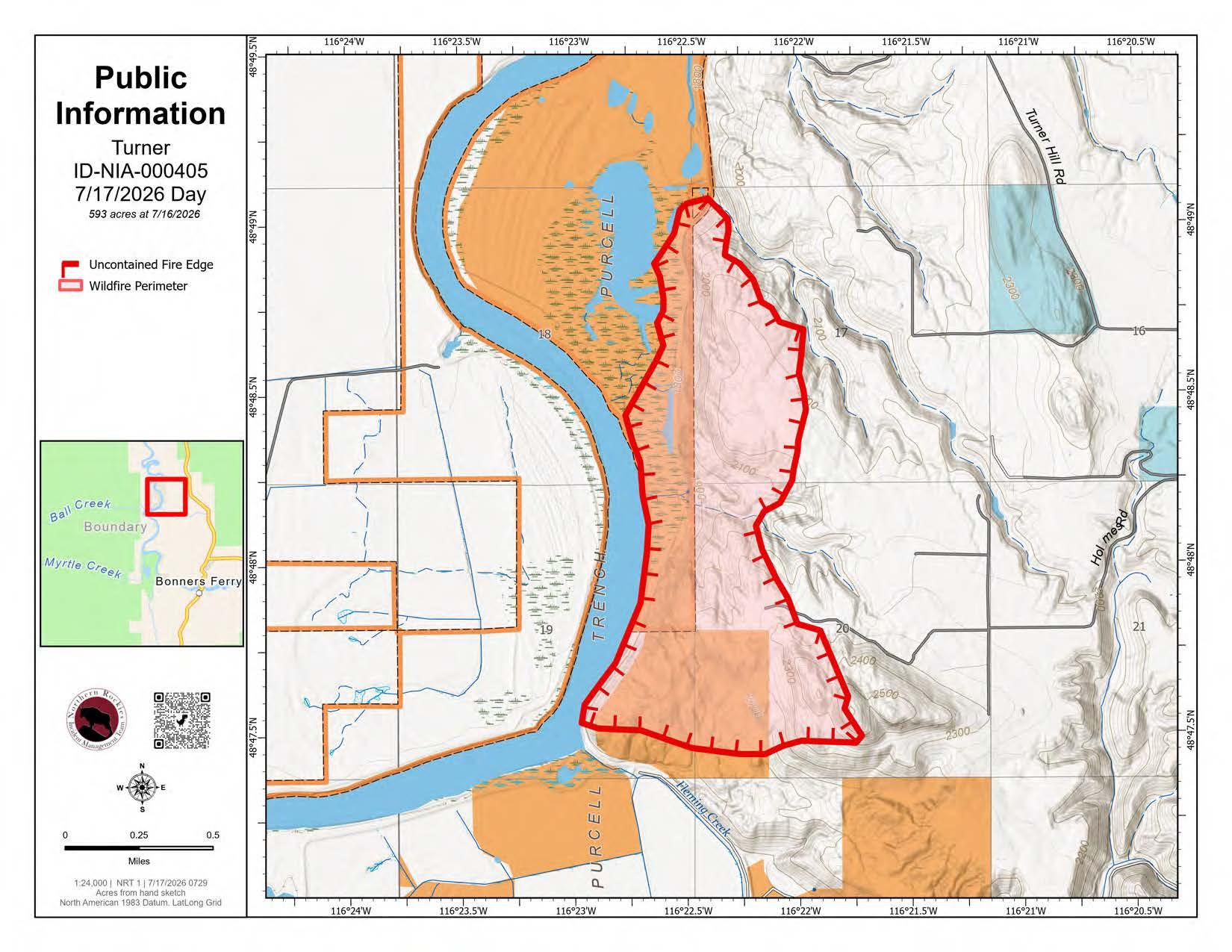
The Turner Fire was reported the evening of July 15 approximately 5 miles south of Copeland. Resources from local, state and federal jurisdictions responded, including many from the Upper Smith Fire. The fire grew quickly due to a significant wind event.
Northern Rockies Complex Incident Management Team #1 assumed command of the fire this morning. A full suppression strategy will continue to be implemented utilizing direct and indirect tactics to protect critical values at-risk and minimize firefighter risk exposure.
Evacuations orders are in place from the Boundary County Sheriff's Office.
| Current as of | Fri, 07/17/2026 - 16:49 |
|---|---|
| Incident Time Zone | Pacific Standard Time |
| Incident Type | Wildfire |
| Cause | Undetermined |
| Date of Origin | |
| Incident Time Zone | Pacific Standard Time |
| Location | Approximately 5 miles south of Copeland, Idaho |
| Incident Commander | Northern Rockies Team 1, Incident Commander Bea Day |
| Coordinates |
48° 49' 30'' Latitude
-116° 22' 49.2 '' Longitude |
| Total Personnel: | 170 |
|---|---|
| Size | 593 Acres |
| Percent of Perimeter Contained | 0% |
| Fuels Involved | The fire is burning in slash, timber, grass and brush. |
| Significant Events | This is a full suppression fire using direct attack where it is safe and effective, while protecting homes and other structures in the fire area. Firefighters will continue direct perimeter control by constructing handline and using heavy equipment to prevent the fire from spreading further onto private and Tribal property in the Kootenai River drainage. Structure Protection resources will work along Fleming Creek and Ginger Roads. |
| Remarks |
Thunderstorms and lightning passed through the area overnight and early Friday morning, July 17th. Northern Rockies Team #1 resources are prepared to respond to any new wildfires starting within the Temporary Flight Restriction area. |
|---|
| Weather Concerns | A Red Flag Warning is in effect until 11:00 a.m. on Friday, July 17 due to isolated scattered thunderstorms that could produce morning outflow winds. Winds are expected to shift in the afternoon to the south-southwest with slightly cooler temperatures and higher humidity than yesterday. |
|---|